
After receiving backlash, DMK supporter Salem Dharanidharan deleted a tweet with a distorted map of India.
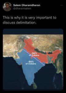
On Friday (November 25), Salem Dharanidharan, who claims to be a former World Democracy Forum and United Nations youth leader but is actually a DMK supporter disguised as a political opinion maker, tweeted an image of India without Pakistan-occupied Kashmir (PoK) and the Aksai Chin area.
He attempted to make an anti-North Indian racist tweet by dividing the distorted map of India into two sections, with a large section of South, Central, and Western India having 50% population, while a small rest of the section of India comprising Uttar Pradesh, Bihar, West Bengal, and other North Easter states having 50% population.
Posting the image, he said, “This is why it is very important to discuss delimitation.” He meant to say that a small section of states with a large population, such as UP, Bihar, and others, are depriving south Indian states with a low population of benefits, thus instilling hatred in them. However, after receiving backlash and being afraid of legal consequence, the tweet was deleted by Salem Dharanidharan.
It is to be noted that the Central government mulled the ” Geospatial Information Bill 2016″ which makes the wrong depiction of the map of India a crime that could land the violators in jail with a maximum term of seven years and a fine of up to Rs 100 crore. This measure has been envisaged by the government against certain social networking sites that showed J&K and Arunachal Pradesh as part of Pakistan and China respectively.
Existing provisions such as Section 505 (2) of the Indian Penal Code (IPC) and Section 74 of the Information Technology (Amendment) Act were invoked against Twitter India in June 2021, when it displayed a distorted map of India on its website.
Click here to subscribe to The Commune on Telegram and get the best stories of the day delivered to you personally.


