
This is part 2 of the series of articles that will explore the long, twisted relationship between China and India. This article focuses on the advantages and limitations of the People’s Republic of China, by looking through the prism of geography and geopolitics. Click here to read part 1.
The oft-told quote is that- “Geography Dictates History”, which is almost as universal as “Demographics is Destiny”.
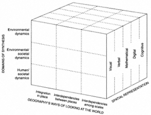
The book Rediscovering Geography: New Relevance for Science and Society gives the matrix of geographic perspectives. It states “Geography’s ways of looking at the world—through its focus on place and scale (horizontal axis)—cuts across its three domains of synthesis: human-societal dynamics, environmental dynamics, and environmental-societal dynamics (vertical axis). Spatial representation, the third dimension of the matrix, underpins and sometimes drives research in other branches of geography.”
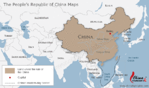
Now, coming to China, or more precisely the People’s Republic of China, the political map looks like this:
The majority of the Chinese population and industry is in Manchuria and on the coasts. However, most of the water supplies, mineral resources and vast lands are in Tibet, Inner Mongolia and Sinkiang/Xinjiang. This means that China faces a massive dichotomy: it must either subjugate the outer lands or again face a potential loss of these in the near future and thus destroy any chances of the CCP to recreate the mythical “Middle Kingdom”.
From a pliant North Korea in the east to a currently friendly Russia in the north, a puppet Myanmar in the south-central region and another lapdog Pakistan in the south-west region, the going looks good for China. Although Vietnam in the south by south-east and Central Asia along the west and north-west remain potential trouble zones. But by far the biggest threat is the Elephant to the south – India.
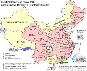
This is a map of China subdivided into its provinces:
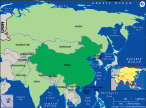
This is a map of China’s neighborhood:
However, the topographical map looks quite different:
Using the brilliant “String of Pearls” tactics (Read: Neo-Colonisation using Dollars and Infrastructure carrots and by selling White Elephants to beggars having huge egos), China has enveloped its neighbour to the South-West, India.
Further, by using a bagful of carrots (read: Investments and Dollars) and doing an “Alliance of the like-minded” with the Russians, they have managed for the first time in over 2000 years of Chinese history to have a relatively secure northern border. It’s from the north – from modern Mongolia and Inner Mongolia (which are historical Mongol areas swallowed by China) and from Manchuria (historical Jurchen and Manchu land swallowed by China) – that China was plundered or conquered repeatedly. Wave after wave of conquerors came from the north. The fertile areas of China are all in the central and south by south-east regions of the modern Chinese State. This is where the economic might rested 2000 years ago and still rests today.
This is a map of the traditional divisions of China aligned with its modern borders.
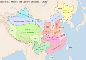
This map will certainly offend the CCP, its acolytes and all modern mandarin Chinese, but it is the closest that comes to the truth about the so-called eternal China or Chinese state.
The potential strengths and opportunities for the CCP and China
This means China’s long northern border can be guarded by militia level troops leaving the better professional troops for the other borders.
The north-western and western borders are part of BARF (no, I am not making this acronym up). Read What is China’s belt and road initiative? here. China is following up its policy of Neo-Colonization using a mix of Carrots (Dollars), Ego Massages (Mercedes Cars and palatial homes to tin-pot rulers of impoverished lands but with gigantic egos) and threats.
Starting with a horde of Enemies from the –
- Mighty USA (the reigning Empire which China fought by proxy in the Korean War) and its allies such as NATO, Japan, South Korea, Taiwan (Chinese Taipei is what PRC insists it be called), Anzacs etc.
- Communist USSR which is now a friend.
- Confused India (which changes politics as per governments and not as per Realpolitik interests).
China has nearly eliminated the threat of the USSR and has befriended modern Russia; it has enveloped the potential threat of India from Land and by Sea. Further the USA has grown relatively weaker in the past 70 years vis-a-vis China. Still the US is a far stronger power than China.
The Chinese have learnt their Sun Tzu well and won’t engage in direct combat till they are sure of victory. They will engage in elimination or reduction of potential threats using diplomacy and politics (as well as economics), staying true to the doctrine of von Clausewitz who had rightly observed that war is just a continuation of politics by violent means.
In this aspect the CCP under Deng and Xi has played a brilliant game. By turning a relatively hostile geography to a relatively benign one, the Chinese have shown that luck can be created (to an extent).
Now let us come to the actual military.
- China will focus on submarine and coastal craft to thwart the larger United States Navy. It will build up a horde of supersonic and subsonic missile systems to potentially threaten the US naval & air supremacy (if and when needed).
- As on date, no other power is capable of going head-to-head with the PLA and emerge victorious. The defense budget is easily $250 billion or more (official figures just lie). Check 2018 China Military Strength.
- China will further keep building its own air-force. Stealth aircraft and a second aircraft carrier are on the table for potential power projections in the Indian Ocean or China Seas (if and when needed).
- Already the Chinese have 2 secret weapons, a currency chest of over $3 Trillion in forex reserves and an army of hackers who can destabilize computer systems worldwide. This is in line with ssymmetric warfare taught by Sun Tzu.
- The PLA’s navy is already the second largest in the world and is brilliant at defensive movements.
- Further, the island building strategy in the South China Sea is to have cheap SAM batteries and cheap missile batteries (anti-ship) and create a first shield or line of defence to protect the mainland.
- The Air Force is the third largest and is modernizing fast.
- The Army is the largest and is also modernizing fast (while shedding excess numbers to some extent).
The potential threats or weaknesses
The biggest geographical constraint for the Chinese is the straits in South-East Asia (Malacca etc), which can be easily blocked by a hostile navy to cut off imports. Hence the whole BARF plan is launched via Central Asia.
The second biggest threat is the mighty US Pacific fleet and other fleets that can pummel coastal China, which is the economic might and agricultural grain yard of the country. They need to protect this core territory and population at any cost.
The third constraint is that the internal movement of troops from North-to-South or East-to-West can be endangered by coalition politics, the likes of which was played by the US till the end of the Cold War. The two Bushes, Clinton and Obama destroyed that alliance by being nincompoops at foreign policy.
Fourth, the Chinese client states like Myanmar and North Korea are extremely fragile and can implode causing mayhem to well-laid plans.
Fifth, the neo-colonial empire may not pay good returns and may result in overstretch and collapse of the core.
Overall, China starts the next potential conflict with a bunch of great cards and a few glaring weaknesses, but weaknesses it understands and is working hard to remedy.


